

Skiing the Southern Alps for Earthquake Revovery
Follow My Journey: Pt 4
Kyle & TJ Visit
September 5th: The Arrival
It was the day I had been long waiting for. My two friends Kyle and TJ were coming to visit. Earlier in the morning I had gone to pickup the rental car. I got really lucky and got a really nice one. I turned in my case study, and went to go pick them up from the airport at 2:30. They were extremely tired and confused when they arrived after their long travels. I took them to Burger fuel, and then we went back to my place. I got my things ready and we set out for Lake Tekapo for the night.
When we got to the hostel, I was hit by some serious nostalgia. It was the same hostel that I stayed in when I stopped in Lake Tekapo during my ski expedition, and also the first hostel I stayed at in New Zealand just days after I left home. We went for a little walk at night to see the stars. We tried to find the path for the observatory but couldn't, and we also knew we weren't going to make it all the way up because Kyle and TJ were very tired. After a little walk we went back to the hostel and hit the sack.
September 6th: Aoraki/Mt. Cook
We got up early and started to drive to Aoraki/Mt. Cook National Park. I stopped to show them Lake Pukaki on the way, but it was pretty cloudy. We got to the National Park, and stopped for a quick snack at the cafe in the hotel. Kyle and TJ had their first meat pies, and they were very pleased! Afterwards, we hit the Hooker Valley track. The track was very easy and quite touristy, but it was beautiful nonetheless.
 Hooker Valley |  Hooker ValleyKyle and TJ on the Swing Bridge |  Hooker ValleyKyle and TJ on the Swing Bridge |
|---|---|---|
 Hooker ValleyKyle and TJ on the Swing Bridge |  Swing Bridge |  View from Bridge |
 View from Bridge |  Hooker Valley |  Hooker Valley |
 Hooker Valley |  Hooker Valley |  Hooker Valley |
 Mt. Cook |  Hooker Valley |  On top of the Rock |
 On top of the Rock |  On top of the Rock |  On top of the Rock |
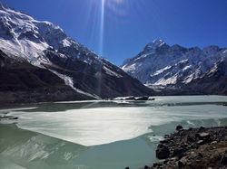 Mt. CookMt. Cook Over Hooker Lake |  Hooker Lake |  Mt. Cook |
 Mt. Cook |  Mt. Cook |  Hooker Lake |
 Hooker Lake |  Hooker Lake |  Swing BridgeOn the Way Back |
 Swing Bridge |  Kyle on the Bridge |  View From Swing Bridge |
 View From Swing Bridge |  Avalanche |
After the hike, we got back in the car, and started to make our trip down to Te Anau where we would spend the night. We stopped again at Lake Pukaki because the clouds had cleared to perfect blue skies. It clearer then it was the day I first saw the lake as well.


Clear Skies Over Lake Pukaki
We continued forth on our way down to Te Anau. We made a pit stop in Queenstown and I introduced Kyle and TJ to Fergburger. The road down to Queenstown was also much better in the 2WD when there wasn't snow and ice on the road. We got to the YHA in Te Anau pretty late. We almost never made it to our hostel before the desk closed during our entire trip, and would always have to call in before hand to get the door code. Nevertheless, we got into the hostel, and I was again hit by nostalgia.


Hooker Valley Track
First Swing Bridge
Hooker Valley
Mt. Cook & Hooker Lake
September 7th: Key Summit & Milford Sound
We woke up in Te Anau and got ready for the day which we planned to spend in Fiordland. I had really wanted to do a hike up to the Gertrude saddle, but when I asked the lady at DOC about the conditions on the track she said it was pretty icy, and none of us had the proper equipment. I was a little bummed, but I asked her about the hike to Key Summit off of the Routeburn track and she said it was a beautiful one. The three of us decided to do that hike.


Views From the Milford Highway
As soon as we got to the car park, I no longer had to worry about Kyle and TJ not being able to see a wild Kea. There were a group of three keas flying around the cars and chilling in a tree.

Keas Chilling in the Tree
We hit the track which took us uphill through the bush and to the turnoff for key summit.


Waterfall
Key Summit Turnoff
After the turnoff, the track climbed steeply above the bushline and up towards key summit. The views of the alps as we emerged from the bush were incredible.


Emerging From Bushline
After the short climb (about 45 minutes), we found ourselves on top of Key Summit. At the top, there was a short Nature walk circuit. We did the walk and had our lunces on top of the lookout.


Key Summit


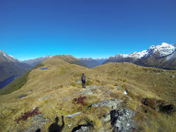
From the Summit, we found a little trail taking us past the pond shown in the bottom right picture. We followed the path which took us through a patch of bush and popped us out along the ridgeline of the mountain. There were incredible 360 degree views of the fiordland mountains. We followed the saddle up to the next peak, and then down past that to some ponds. As we continued along the saddle, views of Lake Fergus and Lake Mckellar came into view.

Our Route

View of Key Summit
Just before entering the patch of bush
Hike Along the Saddle to the Ponds
 Saddle |  TJ on the Saddle |  Fiordland Peaks |
|---|---|---|
 The Crew |  Saddle |  SaddleLake McKellar on Left |
 Saddle |  Saddle |  Saddle |
 Saddle |  Saddle |  SaddleLake Fergus in front of Lake Gunn |
 SaddlePond |  Saddle |  Saddle |
 Saddle | 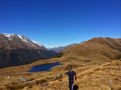 Saddle |  Saddle |
 Saddle |  Mountain Reflection |
 Hiking Back |  The Three Amigos |  Tramping up the Saddle |
|---|---|---|
 Kyle and the Fiordland Mountains |  Embracing Mother Nature |  Kyle & TJ |
 Myself and the Mountains |  Mt. Christina | 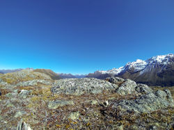 Fiordland |
 Appreciating the Beauty |  On the Ledge |  Fiordland |
 Fiordland MountainsMt. Christina in the Middle |  Fiordland Mountains |
After reaching the pond, we considered continuing up the ridgeline to reach the next peak, but after looking at the time, we decided we would rather turn back so that we could drive to Milford Sound and see it before sunset.
Back to Key Summit


On the way out, I took TJ and Kyle to the wildlife conservation park to show them the birds. I also really wanted them to see the notorious kea just in case they weren't able to see a wild one. We checked out the keas, whistled with the kakas, and saw the takahes before leaving for the start of the Routeburn Track at The Divide. I was interested to see what this part of the track was, because I hiked part of the end that starts in Glenorchy during my fundraiser, but I hadn't done this end of the hike.
The drive was really scenic, and we pulled over a few times to take some pictures.
Key Summit
We got back to the car, but didn't spend much time hanging around because we were getting attacked by nasty sandflies. I set up my GoPro on the windshield to record a timelapse because I had heard that the scening drive to Milford Sound was absolutely stunning.
Milford Sound
The drive to Milford Sound was very stunning indeed. Windy roads through trees, a crazy one way tunnel that was hardly lit and had exposed natural rocks as the sides, and a valley surrounded by large dramatic peaks were some highlights.


Milford Road


I was absolutely blown away by the sights of Milford Sound when it came into view, and completely understood why it was a world famous sight. Mitre Peak towers magnificently from the water surrounded by nearby peaks forming the mouth of the fjord. Once we arrived, we walked to the edge of the shorline for a few pictures, and then stopped at the cafe to have some meat pies before doing a short walk to a lookout. We also drove back and forth down the road for a couple times looking for a visitors center, before realizing that the Fiordland visitors center was in Te Anau (and yes it was the one that I had already been to twice).


Epic Selfie
Milford Sound
Milford Sound
Deepwater Basin

Lookout View
Didn't turn out
After the lookout, we walked back to the sound onto the basin up to the waterline to take some pictures.
 Milford Sound |  Waterfall |  Milford SoundMitre Peak |
|---|---|---|
 Milford Sound |  Milford Sound |  Waterfall |
 Milford Sound |  Oystercatcher |  Milford Sound |
 Milford Sound |  Milford Sound |  Milford Sound |
 Milford Sound |  Milford Sound |
Milford Sound


Milford Sound Sunset
 Sunset |  Sunset |  Posing |
|---|---|---|
 Before |  After |
As the sun started setting, we made the decision to set up a timelapse with Kyles GoPro of the sunset and relax. I found a perfect tree that I climbed up and wrapped the GoPro around one of the branches. Midway through the timelapse, we decided to entertain ourselves by pulling giants logs into the picture and standing them up. Just as we thought, it made the timelapse hilarious and distracting.

Epic Timelapse Setup
 Taking Pictures of the Setup |  Watching the Sunset |  Watching the Sunset |
|---|---|---|
 Watching the Sunset |  Watching the Sunset |  Posing |
 Kyle and the Majestic Sound |  Watching the Sunset |  Sunset |
 The First Log | 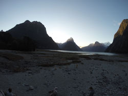 Standing Alone |  Starting to Accumulate |
 Dragging a Giant Log |  Hauling a Giant Log |  Bringing in Another One |
 Final ShotJust before the camera ran out of battery |
Timelapse Photos (Click to expand for the whole image)
After we had our joys making a giant log display and Kyles camera ran out of batteries, we hit the road for a long drive to Kinloch.

Had to snap a photo of this
Milford Road & Milford Sound Timelapse
We got back to Te Anau and stopped for dinner. I tried to look up the number of our hostel in Kinloch but my internet wasn't loading on my phone. So while Kyle and TJ waited in the restaurant, I drove down the street to the Te Anau YHA to see if they had the number. When I got there, they were closed. Luckily however, my internet was loading at that spot. I called the hostel, and the person said they would leave our keys outside on a chair. I drove back to the restaurant, and we all ordered some fish 'n chips.
After dinner, I asked Kyle if he could drive for a little bit so that I could take a nap before we got to Queenstown because I was extremely exhausted. He got behind the wheel, and I got to enjoy a little entertainment while navigating him to the petrol station. It was sometime around 8 or 9, but of course, since we are in New Zealand, the petrol station was closed. We thought we were completely screwed. We drove back to the town center to ask the person at the market if there were any other petrol stations nearby, and as you might guess, the market was closed! Just then however, we spotted a petrol pump on the street corner. We filled up and then payed at the machine (New Zealand really functions well on the Honor code which is really cool).
After that brief saga, kyle took the wheel again and drove us towards Queenstown as I tried to take a nap. I dosed off a few times, but never actually fell asleep. However I was feeling rested enough. Kyle took us through the really windy section of the road running along Lake Wakatipu. We pulled over just before the turnoff to The Remarkables so that I could drive us through Queenstown. We filled up on petrol once again in Queenstown, and then made our way towards Glenorchy.
Once we reached Glenorchy, I had to use the map to navigate to Kinloch, a very tiny town (if even that) near Glenorchy. In fact, on the map, Kinloch is just about right next to Glenorchy, but you have to drive up from Glenorchy, cross the Dart River, pass the road you take to get to the Glenorchy end of the Routburn track and follow Kinloch road until you reach Kinloch. We drifted along the dirt road until we got to Kinloch, and from there we needed no directions as the area was so small and the lodge was one of the first buildings there along the street. The lodge was very remote, and it looked like there were no other guests (we didn't see any guests the next morning). It was also right on the lake and I knew we would wake up to some gorgeous views in the morning. We found our key on a chair right outside the lodge as we were told. Kyle and TJ both crashed, but despite our long drive, I wasn't too tired. I took a shower, sorted some of my things out and then went to sleep. It was pretty funny to realize that it was about a five hour drive to get from The Divide to our lodge, but if you were able to drive straight through the Fiordland woods towards The Dived at 100 kph, it would take less than half an hour (the Routeburn track is 32 km).
September 8th: Earnslaw Burn, Paradise, & Queenstown
Just as I had imagined from the previous night, we woke up to beautiful views of the lake and mountains. We got packed up and made sandwhiches for lunch. I had planned a long hike to Earnslaw Burn (4-6 hr one) and back for the day. Earnslaw Burn is a valley with tons of waterfalls running down from Mt. Earnsla. It also just so happened to be used for a scene in the Hobbit, although everything was helicoptered in. I wanted Kyle and TJ to get a fell of true New Zealand hiking which involved crossing rivers and strong navigation skills in areas where there are no marked trails. This seemed like a pretty good hike to do it.
The lodge had a nice restaurant, and we all went there to fill up on a large breakfast. We really wanted to find Isengard, and I wanted to know where the actual exact filming location was because last time I couldn't find the exact spot but rather just the general area (the entire Glenorchy/Kinloch area looks exactly like Isengard). I asked the manager if he knew of the exact spot, and he said that as we are driving across the bridge over the Dart River towards Glenorchy, if we look to the left then that is the valley of Isengard.
With that in mind, we checked out and started driving toward the Earnslaw Burn trail, stopping on the bridge to look at Isengard.

Isengard!

We continued the short drive until we crossed the Earnslaw bridge, and took a right down a road and parked. We had to cross the river to start, but since TJ just had running shoes that we didn't want to get wet, we walked back down the road and across the bridge. We then walked back up towards the car, climbed a wire fence and began looking for the orange triangle indicating the trail. Kyle spotted the triangle in the bush and we made our way onto the trail.

The trail started off with a steep climb through the bush and then soon popped us out into a tussock clearing.

We continued onward following a orange indicators. After a little while the three of us discussed how the track was pretty long and that we would like to get to Queenstown at a decent hour to be able to book bungee jumping and jet boating for the next day. I also wanted to take them on the scenic drive to Paradise (the road I accidently took months ago when I was trying to get to the Routeburn track). With all that being said, we decided to turn around and hike back to the car.
When we got back to the river we tried to making a little stepping stone bridge with rocks for TJ and Kyle, after screwing around for a little while I told them to just take off their shoes and cross, and so they did.

Tussock Clearing
Crossing the Earnslaw Burn
We got back to the car and tried to spend as little time as possible outside of it because we were being ambushed by sand flies. We ate our lunches inside the car, and would yell at each other to hurry up and slam the door every time they got out haha. We then took off on the Glenorchy Paradise Road, which was the road to the left on the same side of the bridge.


Paradise
We followed the road all the way until it ended at the Dart Track. We got out and walked to the Dart River to take a few pictures, and again we were really fast because we were being eaten by the vicious sandflies.


Dart River
We turned back and set forth on our way to Queenstown.

Goodbye Paradise


Hello Queenstown
We arrived in Queenstown and checked into our hostel, the Hippo Lodge. After the three of us spent a while looking for a really cool place to stay in Queenstown, especially since it was going to be Kyles 21st, and not having much luck with the options we like, I found the Hippo Lodge. We had no idea what exactly it was going to be like, but it was cheap and close to the town so we decided to go for it. When we got there, we discovered it was a really nice find. It was a house with a shared living room and kitchen, as well as two toilets and a shower. There was also a balcony with a nice view of the town and Lake Wakatipu. We had a nice room with a Queen sized bed for the birthday boy and a bunk bed that TJ and I slept on.

View from the Hippo Lodge Balcony
We all took showers and spent about an hour and a half sitting around lazily and doing nothing. We were all pretty tired and it was nice to be able to fully unpack and relax in our own room after nonstop days of traveling.
After a while we decided to go book our bungy jumping and jet boating, and then walk around the town and find something good for dinner.
After walking around for a little while, we decided on a pizza place/bar called Winnies. We ordered a pizza, and when we saw this awesome looking beer tower that another table had we decided to order one of those as well. It was pretty sweet, and we got a t-shirt along with it haha.

Pizza & Beer Tower at Winnies
We took our time eating our pizza, and then set out. As we were walking down the street we ran into Lizzy and Aimee who were visiting the South Island for their mid-semester break. TJ and Kyle said they were gonna go back to the lodge to get some sleep so I decided to hang out with Lizzy and Aimee for a bit. We went to the ice bar, a bar that is completely made out of ice and kept at -5 degrees celsius. It was pretty cool, but pretty touristy especially since the prices drive away the locals. Afterwards I called Grant because I knew he was in Queenstown as well. We met up at Maccas (what they call McDonalds in New Zealand). We talked for a little bit
Afterwards I called Grant because I knew he was in Queenstown as well. We met up at Maccas (what they call McDonalds in New Zealand). We talked for a little bit. It was pretty cold outside and we both stopped by Fergcafe to get a hot meat pie before heading off to our hostels for the night.

Ice Bar
September 9th: Adventures on Kyle's 21st!
It was the day we had all long anticipated, Kyles 21st, and we had in store a day full of activities, the first of which being bungy jumping. We checked in at the booking desk and awaited for the bus to come. We decided to do the Kawarau Bridge Bungy, the spot where AJ Hackett set up the worlds first commercial bungy. The bus arrived, we piled in and got escorted to the bridge.


1st Commercial Bungy
AJ Hackett & Henry van Asch
Kawarau Bridge
We went inside and walked down to the desk to check in. We were thoroughly weighed and then sent off onto the bridge.


Kawarau Bridge
Kawarau River
On the Bridge
View from the Bridge
Looking Down
Kawarau Bridge
View from the Bridge
Bungy Jumping
Kyle was the first up, followed by TJ. Finally, I took my turn at it. I started to feel the adrenaline as they wrapped by heels together with a tower and connected me to the bungy. This was the only bungy jump in Queenstown where you are able to plunge into the water if you want, and I was super excited and ready to go do it. However, they said that unfortunately they had just gotten a new bungy and it wasn't quite streched out enough and that I wasn't quite heavy enough to hit the water with the new cord. They did say that I had a better chance of hitting the water if I took a dive straight down instead of jumping far out.
They helped me up and I hoped over to the ledge. This was of course the scariest part. They had me look around to take pictures, and counted me down from three. I took my plunge. I messed up my jump a little because I was thinking too much about the way I was going to dive, and ended up doing more of a jump off the ledge while forgetting to dive. That part was kind of a fail, but it was still an epic feeling of a short freefall. When you bounce back up the first time I was quite surprised by how high you get slung up. I was swinging around for a bit, and then the guys in the yellow life boat in the water drove out to get me. They held out a long pole that I grabbed a hold of and pulled me down.
 Pre-Bungy | 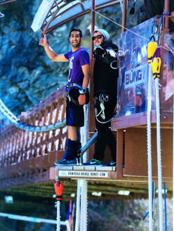 Pre-Bungy |  The leap |
|---|---|---|
 Freefall |  Bungy |  Bungy |
 Success! |


Bungy!
Success!
Jet Boating
The bus came and took us back to Queenstown where we checked into our next adventure, jet boating in the Shotover Canyon! Jet boating is another New Zealand invention. The boat has a powerful engine and is designed so that it skims over water and can ride in water just centimeters deep. The boat is also capable of a full 360 on the water. The driver flies through the canyon and weaves around just centimeters from rocks and cliff faces making it a really thrilling ride. It was really fun and the canyon was really scenic as well.


Shotover River & Canyon
Shotover Jet
After Jetboating, we headed back to our room to shower and unwind for a bit. After a while we decided to walk out towards the Gondola to ride up and then do some luging. We walked to the Gondola, but the luging was closed so we decided we would do it in the morning. We walked around a bit thinking about other things we could do in the meantime. We walked by the Kiwi Wildlife Park which looked pretty cool but was pretty expensive.
Caddyshack Putt Putt


As we continued walking we passed by Caddyshack Putt Putt Golf, and TJ suggested that we should play putt putt. We went in to play a round of putt putt and kill time. Little did we know that we were about to experience the most legit putt putt place any of us had ever been too. Each hole had ridiculous features with movement in sounds such as a rocket ship counting down and then taking off, a ski resort hole where you sent you ball up a chairlift, a volcano that spit out your ball to a random area, a gondola ride, and more. We were mind blown by the place and took many pictures of every hole. TJ had the record with 60+ pictures. I came in dead last while kyle finished in 1st.
 Ski Resort |  Gondola |  Lumber Mill |
|---|---|---|
 Harbour |  Auckland |  Church |
 Castle |
Caddyshack
After a good round of golf we swung back to our room for a bit before heading out for dinner and hitting some bars to close up Kyle's adventurous 21st.
September 10th: Wrapping up Queenstown
We woke up fairly early so that we could hit up the Gondola for a quick round of luging before heading back towards Christchurch.


Van Spotted on way to Gondola
Gondola

The top of the Gondola provided us breathtaking views of Queenstown, Lake Wakatipu, and The Remarkables


Views From Gondola
Luge Track
Just as I was told, the luge track in Rotorua was much better then Queenstown, but it was still a lot of fun. We took two runs, Kyle and TJ had an epic battle on the last one but I was unfortunately too ahead. We rode back down the Gondola and got some lunch before leaving town. We all wanted to eat at different places (I wanted Fergburger of course) so we got our food and met up at the food court.
We finished our lunch and gave our farewell to beautiful Queenstown. Driving up the Crown Range was far better with the 2WD rental when it wasn't covered in snow. We got to Wanaka and stopped at Puzzling World as planned. First we went through and looked at all the puzzle rooms and optical illusions which was pretty cool.

After the puzzle rooms, we took a crack at the Great Maze. There was an easier challenge and a harder challenge. We of course did the harder challenge, which meant we had to make our way to the four colored towers in the order yellow, green, blue and red. We realized that this was the hardest combination, and mulitple times we stumbled upon a tower of the wrong color which didn't count. We wandered around for quite a while struggling, and for a while at first we felt ridiculous because we were three college students and were way behind the average completion time. As we started to figure out the maze we did well and caught up with the time. I forget the actual time it took us but we succesfully beat the average completion time.

Puzzling World


We finished the maze and got back into the car about an hour so before sunset, and continued on towards Christchurch. We were scheduled to return the car the next morning and we would spent the next day packing and getting ready for our evening flight out to Welly! This concluded our adventures on the South Island (with the exception of driving back from the ferry after Wellington). It was a lot of fun and I was glad I got the chance to show my best friends the beauty of New Zealand's South Island.